
About Erice
ERICE, Sicily Erice – about 32,000 inhabitants – occupies a memorably beautiful site. Developed as a Phoenician and Hellenistic town, it sits at a height of 751m, perched on the mountain of the same name, covering a triangular plateau with a glorious view over the sea. Enclosed within defensible bastions and walls, the town is a veritable labyrinth of little cobbled streets and passages wide enough to accommodate one person at a time. The houses, packed one upon another, each have their own charming, carefully-tended, inner courtyard that can be guarded from the gaze of neighbours or passing gentry, and so allows family life to take its daily course in absolute privacy.
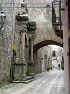
little cobbled streets in Erice
A leap into the past
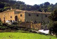
Sweet dreams – Those wishing to experience the pleasure of sleeping in a historical building can do so at Baglio Santa Croce, in Valederice just below Erice, a 17C farmhouse that has been transformed into a hotel, but yet retaining its original fabric. Peace and seclusion are assured by the fine terraced gardens.
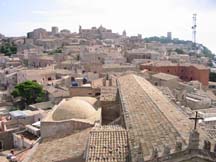
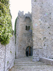
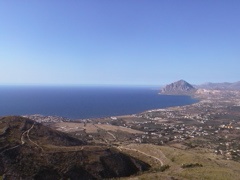
Access – Both the two roads that wind up to the town afford superb views across the plain and out to sea (the one on the north side, overlooking Monte Cofano, is easier). The little town takes the shape of a perfect equilateral triangle, whose symbolism has provoked mystery and endless argument: hemmed in by the Castello di Venere (south-eastern axis) and the Chiesa Madre (south-western side). Exactly in the centre of the triangle is the Church of St. Peter with its adjacent monastery that now houses the E. Majorana Centre for Culture and Science. An intricate maze of narrow streets, each cobbled with rectangular stones, provides unexpected glimpses of churches and monasteries, of which there are over 60, scattered through the town. It is advisable to park at Porta Trapani.
 Baglio
Santa Croce
Baglio
Santa CroceChiesa
Matrice – The town’s main church is situated near Porta di
Trapani, one of the entrances to the town. Built in the 14C, principally
using stone from the Temple of Venus, its massive form and merlon-topped
walls suggest it was intended as a church-fortress. The façade
is graced with a fine rose-window (replicating the original), that is
now partly concealed by the Gothic porch that was added a century later.
Inside, fashioned in Neo-Gothic, sits a fine marble altarpiece from the
Renaissance. Bell-tower – The lonely tower to the left of the church
was originally intended as a watchtower. The first level has simple narrow
slits, while the upper section is graced with fine two-light Chiaramonte-style
windows. The top is crenellated with Ghibelline merlons.
Museo Cordici – Accommodated inside the town hall is the local museum
which collects together various archeological finds, statuary and paintings.
Notable exhibits include Antonello Gagini’s sculpture of the Annunciation
(1525) and, on the first floor, beyond the library containing manuscripts
and early books, a small marble head of a woman, modelled on a Greek original.
A little further along, on the right of the piazza, is Via Cordici which
leads into the picturesque Piazza San Domenico, lined on one side by a
street of the same name and on the other by elegant palazzi.
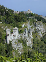
Giardino
del Ballo – The lovely public gardens are arranged around the Castello
di Venere and the Torri di Ballo which were built by the Normans as a
forward defence for the castle. The towers and gardens are named after
the Norman governor (Baiulo) who once lived on this site. The glorious
view embraces Monte Cofano, Trapani, the Egadi Islands and, on a particularly
clear day, Pantelleria and, possibly, Cap Bon some 170km away in Tunisia.
Castello di Venere – The 12C Venus’ Castle is appended to
the very tip of the mountain, looking out over the sea and the plain below;
although the present building is Norman, the site itself has a more ancient
history. Indeed, it was once occupied by a temple dedicated to Venus Erycina,
who became completely associated with Aphrodite especially after a temple
was dedicated to her in Rome (217 BC) when she gained popularity. By the
time the Normans were in occupation the temple was in ruins, and so it
was decided that the area should be cleared to make way for a fortress
surrounded by great walls: the complex was designed to exploit the strategic
nature of the site and have the added protection of forward defences in
the form of towers (Torri del Ballo) that would once have been accessible
from the castle by a drawbridge. Its defensibility was further emphasised
by the machicolations above the entrance. This provides a perfect viewpoint
from which to survey Trapani and the Egadi lslands to the southwest and,
to the north, the towers, the Pepoli turret (down below), San Giovanni,
Monte Cofano, the coast around Bonagia and, if the weather is fine, the
island of Ustica.
Castello di Venere
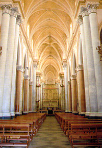
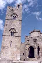 Chiesa
Matrice
Chiesa
Matrice
Elimo-punic Walls – A mighty wall was built by the Elimini (8C-6C
BC) around the north-eastern flank of the town – the only section
open to possible attack. Massive blocks characterise the lowest and most
ancient stone courses which were built up through successive ages with
smaller components. The skyline was punctuated with lookout towers, steep
stairways provided access to the chemin-de-ronde, while small openings
allowed residents to come and go freely and for supplies to be imported.
The best-preserved stretch of walls runs along Via dell’Addolorata,
from Porta Carmine to Porta Spada.
Santa Orsola – This church, built in 1413, preserves its original
Gothic rib vaulting down the nave. It is here that the 18C Mystery figures
are kept when not being processed around the town on Good Friday before
the Easter celebrations.
Quartiere Spagnolo – From the top of the so-calted Spanish Quarter
building, initiated in the 17C but never completed, there is a marvellous
view over the bay of Monte Cofano and the area beyond, and down towards
the tuna fishery at Bonagìa.
IN THE VICINITY
Tonnara dl Bonagìa – Approx 13km to the north. Drive down to Valderice and continue towards Tonnara (from the main Valderice road, turn left at the super-market). At Bonagìa, follow signs for the Tonnara (tuna fishery) while looking out for its distinctive tower. The tuna fishery, set up in the 17C, was once a simple self-contained village: clustered around a large central courtyard were the fishermens houses, facilities for cleaning and processing the tuna, the boathouse (now a conference centre, although two examples of fishing-boats remain) and a small chapel where the tuna fishermen used to assemble before going out to sea. The Saracen tower, intended for use in defending the place, now houses the Museo della Tonnara, a small museum displaying the tools and equipment required in building and repairing boats, fishing and the initial stages implemented in sorting and processing the fish. On the second floor, a scale model shows the long corridors of
net that the tuna must enter before reaching the last chamber made of very strong twine, known as the camera della morte (death chamber). It was here that the cruel mattanza (the kill or slaughter) took place. Today, the tuna fishery accommodates a large hotel complex.
home | Committees | Registration | Program |Accommodations |About Erice | Publication Proceedings